Thursday, April 28, 2011

Boring Beautiful Caching – my 1500th find

on a 20k hike 'round Germany's "forest city"

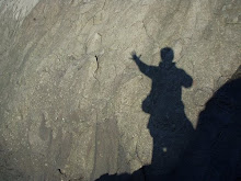
The crazed eyes of an obsessed geocacher with his 1,500th find.

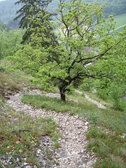
My 1500th cache was as boring as the first 1,499: a beaten path leading to a stump, rocks piled neatly between the roots, hmm I wonder where could the cache be?

My 1500th cache had no view, no real challenge, nothing interesting about it all. Except it was part of a fantastic 20km hike through the woods of north western Germany.

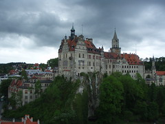
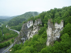
We found 31 caches that day on a six-hour tramp around a hill called Froensberg, to the south of Iserlohn, on the western edge of Sauerland. Sauerland (meaning “southern land”) is a hilly densely-forested area along the southern edge of North Rhine Westfalia. Iserlohn (96,000) is the biggest city in Sauerland and is nicknamed the “forest city.”

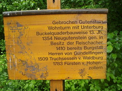
I first noticed Iserlohn as I was scanning the new maps on geocaching.com and noticed the area is blanketed in caches… a cacher with the nickname “Froensberg” hid two big series in the hills there – one with 8 caches plus a bonus (Rund um Froensberg) and the other with 18 caches plus a bonus (Froensberger Bergtour).

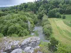
The rolling rural landscape of Sauerland

Cache series like these make hiking in unknown territory a breeze. You just go from waypoint to waypoint to waypoint. It’s like having a local guide along to point out the interesting spots and to tell you which path to take.

fotos from froensberg

After studying the maps a bit, I combined the two hikes into one big round trip – with only one short bushwhack. Froensberg mentioned the terrain was quite hilly so I wasnt sure if we would have the stamina to find all 31 or not… so I made notes of points on the hike where we could turn for home.
The really interesting thing about geocaching (and hiking in general) is you never know if things are going to work out exactly as you plan.

Since it was Easter morning, Heike and I compromised on a 9 am departure time. A pleasant and gemütlich breakfast and then we hit the highway. Froensberg, ever the perfect guide, had provided parking coordinates and we just plugged those into the Sat Nav and drove. One hour later we were pulling on our hiking shoes and soaking up the beauty of the rolling hills of Sauerland.

Clouds of pollen over the forested slopes of Froensberg

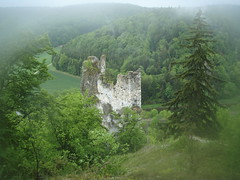
Froensberg’s first cache was one of the best; also a stump only 300m from the car but situated atop a knoll at 475m altitude with a 360° view. Nothing but forests and sunshine all around. We knew then it was going to be a good day.

Our guide then led us down through a stand of tall beeches and oaks to a spot overlooking the village of Froensberg itself (pop. 330). Here we picked up a couple extra caches and left the first series (Rund um Froensberg) after station two. Time to bushwhack to station 18 of the second series (Froensberger Bergtour) and find that series in the reverse order. If everything went to plan, we could just pick up the first series again where we left off.

We plunged into the beech forest and quickly hit on a game trail that led us to beaten path that brought us to a woods road which seemed to be going our way. For a while.

Spider-woman. Pollen on a spiderweb.

Back into the woods up a steep slope and onto another road and a junction and we started the second series. From station 18 we just followed the series backwards to station 1.

There are zillions of trails and woods roads up in those hills – and sometimes, because we were naviagating backwards, we couldnt be sure which trail Froensberg wanted us to take. But all in all it was child’s play and the trails led us by breath-taking views of more forest and more slopes.

The pollen was falling heavily – everytime the wind blew we could see huge yellow clouds blow up from the hills across the valley. We ourselves were walking in yellow fog the whole day – by times it was hard to breathe and my eyes got scratchy like I had left my contacts in overnight.

The weather was otherwise perfect – sunny and high 20’s with just enough breeze to keep things comfortable. No bugs and no humans all day.

Numbers 1499 and 1500 were especially banale. I imagine Froensberg hid these two more as trail markers. – not as he often did to mark spots with a good view or good places to rest. 1500 was at a trail intersection beside a pond the fire department uses for filling their pumpers.

I wonder where the cache could be?

My log entry:

********* my 1500 th find *********
– !! woohoo yeehaw yabba dabba doo !! –
a great big thank you to the owner, Froensberg, for helping me mark the milestone with a super hiking tour exactly the stuff i love about caching – great views, challenging trails, peaceful clean wilderness
many many thanks!!

herzlichen dank an froensberg dass ich den Milestone mit dieser tollen runde feiern dürfte
(die runde ist echt klasse gemacht )

14.10 pm
a quick and easy find – seems a long way for the fire department to come for water…
15th of 31

There was no view and no spot to relax here so we postponed our celebratory picnic til the next cache, Froensberger Bergtour 8 . There was a big stretch of (pollen-covered) grass there under a couple oaks with a great view down the valley. My log:

Yellow feet at the end of the day. The fine pollen grains passed right through our boots and socks.

14.30 pm
took a long break here to celebrate #1500 – brötchen mit (kaltem) bratwurst, köpi, milka und haribo – a german feast

When we took our socks off here to put on fresh ones, we discovered our feet had turned yellow with pollen. After a quick nap in the shade we set off again determined to find 15 more.

The trail led us up into the hills and down, along a sweet winding footpath, back onto public hiking trails and then, a couple hours later, at 4.20 pm, up up up to “Froensberg Bergtour 1″. This was the last cache for us in this longer series of caches.

We sat down on a stump to figure out the bonus. In the logbook of every cache we had found six smileys of different colours.

Easy-going trails through beautiful landscape on Froensberg

There were no clear instructions about what to do, but it seemed maybe we should add the number of smileys for each colour and subtract those numbers from another set of numbers in the bonus description…

Anyway we came up with set of coordinates that seemed entirely possible and just happened to lie on our path back to the first (shorter) series (Rund um Froensberg).

And sure enough, between the roots of a tree under some neatly piled rocks we found the bonus. Considering we had done the tour backwards, it was a big stroke of luck that the bonus would be located so conveniently for us. From here it was only another 200m to pick up the first series where we had left off.

We could have actually easily headed home from here (we were back in the village of Froensberg) but with only seven more caches to go, it would have been a shame to stop.

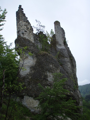
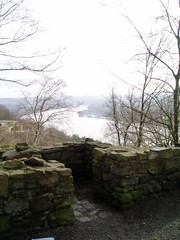
The last few caches were among the most interesting – there were great views of Islerlohn, there was a burial mound or barrow, and a couple of tree hugger caches – where little beech trees were growing around older firs.

An hour later we found the last cache (between roots under neatly piled rocks) and sat down to figure out this bonus. The coordinates led us to a little field overlooking our parking spot.

On the edge of the field was a hollow stump with a tidy pile of rocks inside….

fotos from froensberg

Saturday, April 23, 2011

triple tasking on the run

Running over a coal dump with coffee at The Slab

The Slab atop Schurenbachhalde

I have always loved jogging around a new town or a new neighbourhood, even down a new trail or along a new beach. there is no better way to explore new-to-you territory: you can stop whenever you want, you can cover lots of ground, you can plan an out-and-back or a loop, you can change your mind and take a detour through a park, or just sit on a rock and watch the waves.

when i think of my best all time runs, it is always the exploration runs: over the rocks and sand of clam harbour, nova scotia, through the fog of port-aux-basque, up and down and up and down the steps of signal hill in st. john’s, along the seine in paris, into the dunes in holland.

and now, over the schurenbachhalde or coal dump in the north of essen, germany, where ive been working and living on and off for three years.

(of course, on days like today, before i sat down to type this up, my simple morning run was also fantastic: a crazy colourful sunrise mixed with thunder clouds, wild bird song in the woods, reflections and geese on placid river, rain smell on hot pavement, totally soaking downpour – pure straightforward glorious fun)

thats another story: this one is about yesterday’s run, a triple combo of run, explore and geocache.

more fotos from schurenbachhalde on picasa

Das Treppchen - 263 steps of the Schurenbachhalde

essen you have to understand is a former coal-mining area and as such it is literally covered in little artificial mountains – piles of coal tailings, regenerated, renaturated, plastered with gravel paths and muddy trails and monuments to the area’s former industrial glory – there are also playgrounds and lots of unexpected “natural” features – in short, a runner/ explorer’s paradise

of course these former mining sites can be huge and the web of trails confusing – which is where geocaching comes in – i use the coordinates of these silly film canisters, plastic tupperware containers and ammo cans to guide me round through the unfamiliar landscape – so i can be totally lost and still know exactly where the car is

i had been caching here twice before but always on my way home from teaching – in the wrong clothes for really exploring – yesterday was the first morning of a five-day holiday and i wanted to do something special

i woke before my alarm at 4.45, filled a thermos with coffee and headed north through the centre of town and the already heavy morning traffic – i actually got a little lost and ended up in gelsenkirchen but basic knowledge of local geography helped me out – the ruhrgebiet is bordered by three rivers: the ruhr to the south where i live, the emscher marks the northern edge of essen and the lippe is farther north again. so from gelsenkirchen i just followed the emscher back west towards bottrop

happy and filthy under the steps of the schurenbachhalde

I parked at the “main entrance” to the Schurenbachhalde, just below the coal dump’s 263 steps – my first cache was actually hidden under the metal steps – but where? – the first clue was under step #189 – a nice warm up – then crawling and squiriming on my belly in the dirt and dust – then up a few steps, down a few steps and … i found it – a nice big ammo can container

one main reason i came here so early was to do the crawling and squirming before the joggers and dogwalkers showed up  – it is exactly this kind of childish fun that i love about geocaching – be honest, who doesnt just love getting good and dirty?

i actually had a bit of an asthma attack under the steps – the dust and leaf mould is pretty rough -  i jogged up to the top of the halde, chewed some mint gum (always opens my lungs) and sipped coffee from my thermos with my back against Die Bramme

View from Schurenbach: pure Ruhrgebiet, industry mixed with green

the top of this dump (like many here) has been turned into an art installation – a smooth gravelly moonscape stuck with a massive slab of steel – Die Bramme ( German for The Slab) is 14.5 m high, 4.2 m wide, 13.5 cm thick, and weighs 67 tons. it is freaking big. It was erected here in 1998 by American artist Richard Serra at a cost of €1 million.

(there is a cache hanging from the side of the slab – way up near the top – by powerful magnets – a T5 – the highest terrain rating possible – out of my league)

it is fantastic up here at any time of day or night – the 360° view is breathtaking – and pure ruhrgebiet – green expanses of woods and rivers broken by smokestacks, cooling towers and haldes all around.

theres a great view of scholven, about 10k north, one of the largest coal-fired power plants in europe – unmistakeable with its seven cooling towers, two smokestacks over 300m high, and its coal dump topped with windmills – scholven has an installed capacity of 2300 MW and is capable of covering 3% of Germany’s electricity needs (2300 MW also just happens to be Nova Scotia Power’s total electricity-generating capacity)

Sunrise over Gelsenkirchen from Schurenbachhalde

yesterday i watched big clouds of steam billow from the steel plant in bottrop, watched the flare dance above the refinery in gelsenkirchen while ever so slowly the sun peaked up over the horizon to the east

time to get running again. down the steps along the main path to a neighbouring coal dump – eickwinkel – this one with tiny winding trails overgrown with brambles and vines – a jumping ducking twisting run – two quick caches – one down near the stink from the emscher (sewer) canal – then over the main canal and a final cache – watched steam rise from water pumped up from old and slowly flooding mines

i would never have found my way through this labrynth if not for the cache coordinates – this is a part of town i might never have explored if not for geocaching – and running – a great triple combo morning of exercise, exploration and fun

wait a minute – make that quadruple combo -its also a great place to take pictures:

more fotos from schurenbachhalde on picasa

Wednesday, April 06, 2011

#10 on my list of Top Ten Castles in Europe: Gebrochene Gutenstein

P5180126

Gebrochen Gutenstein dates back to the 1300s.

There are zillions of castles in Europe. They’re literally laying around all over the place. Europeans take them for granted the way we in Nova Scotia take miles and miles of empty coastline for granted.

Number 10 on my list of favourite castles is a ruins in the hills, a forgotten pile of rocks.

I literally stumbled on Gebrochen Gutenstein (Broken Goodstone) while on assignment in southern Germany.

I was writing for the German army for a couple weeks in Sigmaringen (pop. 15,000). This little town lies on the banks of the Danube River, in the limestone hills to the south of the Black Forest, in a wild and wooded area known as the Schwabish Alps.

I didn’t need to leave Sigmaringen to go castle hunting. Schloss Sigmaringen towers over the river valley from atop a steep-sided projection of chalk right in the middle of town. The orginal castle was built on this obvious site in the Middle Ages starting in the early 1100s. Subsequent owners added to the castle over the centuries – with final renovations and additions in the late 1800s and early 1900s making for an eclectic combination of Romantic, Gothic and Renaissance styles.

A gorgeous piece of architecture, but what I wanted was adventure. I rented a bike from our friendly hosts at the Fürstenhof Hotel and rode west.

P5170294

Schloß Sigmaringen towers over the town and the Danube River.

I headed downstream on paved bike paths along the banks of the Danube, cruising by grain fields, through tiny villages for a few k until the bike path petered out in a gravel parking lot – the parking lot for the “Princely Parks of Inzigkofen”.

I climbed a bit on steep cliffs directly over the Danube with flotilla after flotilla of canoers paddling beneath me. The day turned wet and, when the skies suddenly opened in a warm downpour, I hid for a while in a limestone cave and then later took shelter under the “Devil’s Bridge”.

Both sides of the road were lined with trails leading up into the cliffs and I explored them all, racking up a little over a kilometre in vertical, and fully covering myself and the bike in mud.

P5180040

Playing on cliffs above the Danube just west of Sigmaringen

To be honest I wasn’t wandering completely aimlessly: I had a hand-drawn map with X’s marking a dozen geocaches; I almost decided against “Gebrochen Gutenstein” because it’s a little hard to get to from the bike path – it’s on the wrong side of the highway and you can’t just cross over the road. You have to instead bike for a couple k on the narrow winding shoulderless pavement with cars and trucks whizzing by.

I gratefully pulled into the rest place on the L277 and began to regret the whole detour. Rest places in Germany are not pretty spots – the only people who stop in these places are people who cant drive any further – people who have an urgent task to take care of – and when they discover there are no toilets, they rush off behind a tree.

P5180096

My first indication I might be seeing a castle ruins

The first indication of a castle ruin came from a little wooden sign with a brief history of Gebrochen Gutenstein – most of it was gobbedlygook and I really only learned from the sign that a castle was built near here in the 13th century.

My GPS indicated the geocache was uphill, almost directly overhead but there was no clear trailhead – just two or three muddy unofficial-looking paths leading down through the ditch and into the scrubby brush – more like toilet trails than hiking trails.

I followed the most promising of them and sure enough it soon headed up hill more or less in agreement with my GPS. Naturally though the cliffs and trees blocked the satellite signal for my GPS and there was nothing to do but head up and hope for the best.

P5180122

The trail to Gebrochen Gutenstein

The trail, steep in parts and constantly switching back, was only about 30 cm wide, but thanks to the white limestone gravel, easy to follow and to walk on.

The strenuous trail pushed the highway and yucky rest area from my mind. Soon I was looking out over the Danube River Valley with tendrils of mist, thanks to the sun-showers, rising from the fields and riverbanks below.

After maybe 15 minute of climbing, the trail turned up a narrow gulley between two walls of smooth white limestone. I kept climbing another 200m or so until I finally reached the top of the trail. A thick forest barred the way in front of me. I looked left and right but there was no sign of a castle or even ruins.

Only when I turned right round to look down into the valley did I realize the castle was behind me, on top of an outcropping of limestone.

The ruins were breath-taking: drab, weathered white limestone contrasting against new spring green with mists curling around the whole scene.

P5180115

Lost in the mists above the banks of the Danube

and then my imagination began to spin. the walls have been balancing up there for 700 years. this was a different more dangerous world back then and this spot high above the river provided some safety.

i thought of all the work it must have been to build the place and tried to imagine the lives of the people who lived and laughed and toiled in there.

i think part of the allure of Gebrochen Gutenstein for me is that you can walk right under it, run your hands along the old walls, but without a rope and some sharp climbing skills, you can’t get into the castle.

Ive included this simple pile of rocks in my list of Top Ten European Castles to represent the zillions of fabulous ruins that dot the landscape over here, the ones you’ve never heard of. This spot wasnt mentioned in any of the tourist info I read or even recommended to me by any of the locals I spoke to.

P5180110

Gebrochen Gutenstein is easy to miss among the limestone cliffs

And yet it was a highlight for sure of my visit to Sigmaringen. The site is so fantastic; below the romantic secretive Danube, to either side the limestone cliffs at once hard and unyielding while also visibly, steadily eroding away and all around the dark quiet forest.

It confirmed for me that my way of exploring Europe is the right one for me: no plans, no major cities, just following my nose (and my GPS), up hill and downstream, taking a real good slow look round on the road less travellled.

Sure I get muddy and sweaty, but that makes the bratwurst and beers taste all the better; sure I often get “lost”, but that’s when I find make the most interesting discoveries.

(The next installment in this series will be a bit shorter, mostly because it’s about a castle I havent been to yet but dearly want to see some day… on France’s Atlantic coast.)

12 fotos of Gebrochen Gutenstein and surroundings on flickr

Sunday, January 30, 2011

Four kinds of Geocaches, all kinds of Fun

Sun mud trees trail, run jump climb and sign

The day off: Im climbing me some trees

Friday I found four different kinds of geocaches.

Okay not a very sexy start to this post. How about: “I spent six hours running around the woods of Germany, soaking up the sunshine, climbing trees and getting good and muddy”?

By lucky coincidence, I had the whole day off while at the same time Mr Sun, Mr Golden Sun showed up for work for the first time in ages. There was no question I was spending the day outside.

I took the dog and went for a couple hour run through Oberbusch, a woods to the north of Ratingen, a small village outside Düsseldorf.

Lasti and I know these woods pretty good having run/ cached here a lot in the past. There were a couple new caches however. An easy “Puzzle” cache and a tree-climbing “Multi”.

“Huh?” I can hear you asking, “I didnt even know there were different kinds of geocaches.”

A gorgeous sunny winter day in the woods of Germany

According to geocaching.com there are eleven official types and four “grandfathered” types.

The easiest to describe is the Tradi or traditional cache. The coordinates posted online lead you directly to the cache. (Dont confuse type with container size; cache containers come in all shapes and sizes.) Tradis are the most common, especially in Canada.

Here in Germany, they tend to favour Multis and Puzzles.

To find a Puzzle cache, you have to “figure out” the coordinates. My first cache today was an easy one, based on that super famous Cambridge study:

It dsnoet maettr waht oderr we put the leertts in as lnog as the fisrt and lsat leettrs are in the rhigt sopt.

I just had to unscramble the coordinates as below (but in German, eh)

fvie one ttwney trhee ponit fuor stxiy seevn

and then find the cache.

Up into the hills above Kupferdeh

The real attraction to Oberbusch though was the new Multi; a type of cache where you have to find a series of stations (and usually clues) leading to the Final. For this cache, I had to climb six trees and look around in the branches for the clues. Too much fun.

The woods paths were mostly soft

and leafy and great for running on; the swampiest muddiest spots were thankfully just frozen enough that I didnt get wet. Strangely there was no one in the woods and we could run and jump and climb and hoot as much as much as we wanted.

Found the final and headed home for lunch. If you’re counting, thats two cache types and three hours of sunshine before lunch.

After lunch I headed down river to Kupferdreh and then up into the hills. My first find was a Tradi called Quicky in a town park. It did only take about 5 seconds to find, 30 seconds to sign and rehide. Most Tradi’s are quick which is why Germans dont like them. They prefer the thrill of the hunt, a long search leading up to a big climax.

There was no "treasure" at this Earth Cache, just the imprint left by 320 million year old trees.

I spent another three hours up in the hills. The low warm winter light was gorgeous in the beech woods, casting long shadows on the blanket of rusty brown leaves. All that time I was on the trail of a Multi which I never did find. Which is whay Canadians dont like Multis: you spend all kinds of time and energy trying to get one, buy her a few drinks and then go home empty handed. Oh, I mixed my metaphor there. But you get the point.

I did however log an Earth Cache. For these caches you dont actually have to “find” anything, but you visit sites of geological interest, learn about the geology there and send answers and fotos by email asking for logging permission.

This Earth Cache is a former sandstone quarry where you can see the imprint of trees that fell into a swamp 320 million years ago. Hard to get my mind around that number.

What does it mean? It means the trees were here a really long time ago.

What does it mean that I found four types of geocaches? Not much really. Just means I was pretty busy Friday and saw a lot of country.

Foto sets from Friday on Flickr

Trees of Ratingen

Kupferdreh’s Gorgeous Churches

Caching round Kupferdreh

Tuesday, January 25, 2011

Top Ten Castles in Europe (Intro)

from the point of view of a Canadian living in Germany


P1010023

Isenburg: the ruins of an 800 year old castle no one bothers to mention.

Castles are everywheres in Europe; on every cliff top, above every river, in every city there is one or two. If not a fully restored citadel-turned-museum complete with parapets and towers and suits of shining armour, then at least a hidden eerie ruins overgrown with creeping vines.

Europeans pretty much take them for granted. They grew up with them and were forced as children to visit them on school trips.

They don’t always quite understand the North American fascination with castles. Case in point, I’ve been living in Essen for three years and not until last week, did I discover, quite by accident, Isenburg, the ruins of an 800 year old castle just around the corner from me.

A dozen photos of Isenburg on flickr

P1010018

My German friends couldnt understand me crawling around exploring these ruins for an hour

When I say “discover” I dont mean to imply I was the first person to stumble on this place – but it was honestly almost that hard. Not once in the last three years, in none of the zillions of conversations about what I “really must see” did anyone ever mention Isenburg to me.

Admittedly there isnt a lot left of the castle; when it was destroyed in 1288, it was the largest structure in Essen but now there are just some partial walls left standing, some half-buried overgrown foundations poking out of the undergrowth, a moat and a restored drawbridge, some steps, and lots of scattered rubble – but more than enough to stoke my imagination.

I spent an hour up there on the “ramparts” dreaming a bit and just soaking up the atmosphere of the place – something my German friends couldnt understand.

P1010012

Looking down on Lake Baldeney from the ramparts of Isenburg

This got me thinking about all the other castles I’ve seen in Europe. And I have to admit, Im starting to lose count. I figure it’s time I write a little about them. So I’ve decided to crank out a list of my top ten favourite European Castles.

To be frank I havent been that far afield. Ive seen a few castles in France and Belgium and lots and lots in Germany. Nonetheless I have seen some really fantastic ones: Ive seen first hand the inspiration for Disney’s castle, Ive toured the robber castles of the Romantic Rhine, and hiked the hills of northern France, climbing through grapefields and woods of wild boar on my way to forgotten hilltop outposts.

Best of all was sneaking through a recently abandoned castle, climbing right to its upper tower, all the while watching out for the owners and their guard dogs.

Enough anyway to make a good list.

First in the series: #10 Gebrochen Gutstein (Broken Goodstone); ruins on the Danube (Ed.note, 25.1.2011: Ill add the link here soon – as soon as Ive written the first entry )

Friday, January 07, 2011

Rainy days are dreaming/ planning days

Canal skating in Holland and Horn Sledding in th Alps

Unexpectedly have the day off; a wet slippery icy day off. So I skipped running on the ice in the dark this morning in favour of running on the ice this afternoon in the grey light of winter.

And so Im staying in this morning and catching up with a few twitter favourites that i never got to watch. Like this inspiring little two-minute clip of ice skating on the frozen canals of Holland.

Dutch Winter from Kasper Bak on Vimeo.

Dutch Winter from Kasper Bak on Vimeo.

I say inspring cause i immediately jumped on google to see where and when i can go. found this extraordinarily helpful blog: 10 things i learned about skating in holland.

pointed me to the Royal Skating Union’s website which lists planned canal skating dates.. end of january is full of events… id feel more confident about it happening if it wasnt all of a sudden +10 here today…

anyway, ive added it to THE LIST and if the weather turns around, and im still here later this winter, then im going skating on the dutch canals. if not, maybe on the ottawa canal? (maybe ill just add “canal skating” to the list, to be safe)

and then i stumbled on some crazy footage of Horn Sledding on Wank Mountain in Bavaria. Despite the ridiculous names involved, it really made me proud for my little German friends. From my experience here in Essen, they cant drive in snow, they cant shovel it, they are just useless. But they sure can tobaggan.

Horn Sledding was a traditional method of transporting wood or hay off the moutain. Check this short vid from 1934:

The modern race came, like all good things, from a bet. Six sleds took part in the first race on Januraty 6, 1970.

Tell me this doesnt look like fun:

that was german style hornsledding from garmish. below is what the italians (in Olang, Tirol) do with hornsledding:

hmmm… truly stoked for my run now…

Tuesday, January 04, 2011

Resolutions. Schmesolutions (Saying goodbye to the disposable coffee cup and to resolutions)

To resolve or not to resolve? That's the question.

Im usually big on the New Year's pledges. Big on making the promises. Small on following through.

I forgot til I just looked it up, how many stupid resolutions I made last year. (No, Im not linking to it. Hmmh).

But the other thing I did last year, which Im liking better than resolutions anyway, is set 101 goals to accomplish within 1001 days. I call it "The List."

Ive knocked off 16 of those goals, 85 to go with 847 days remaining. It's fun. The big goal is of course to check off all 101 but it's real rewarding to knock off the little goals as you go.

I only stayed serious about one of my original traditional resolutions last year: I wanted to avoid using disposable coffee cups. By Jan. 7th Id already used two. By the end of June Id hit four and it wasnt til the third week of December, that my number slipped up to six.

Travelling is the hard part. Ive easily eliminated the disposable coffee cup from my daily life. I have my own mug at work and if I buy a coffee out, I sit down and enjoy it properly.

Four of my sins this year came while on the road with a group. Things get harder to control. And one thing I have no control over at this point: I need good strong coffee at good short intervals.

I am working on the coffee addiction and am down to three mugs a day.

Plus Santa offered some help going forward: my shiny new coffee thermos should help me avoid a few of those mid-drive coffee panics. And Im just going to have to say no in the future to the well-intentioned offers of my travelling companions.

Cause in 2011, I resolve to use not one single disposable coffee cup.

Do me a favour: dont let me forget!